Landscape and Archeological Sites
per person
Landscape and Archeological Sites
In Yeruham, you can find a variety of interesting and archeological sites, such as the Israeli Fortress, Yeruham Stronghold, Yeruham
Well, Mt. Avnon and the Mandate structures, Yeruham Lake Park and more.
Yeruham Park is west of the town. During the 1950’s, immediately after “Kfar Yeruham” was established, KKL took part in the settlement endeavor and planted trees. In the 1980’s, it extended its planting effort to surround the lake, preparing widespread lawns and an adventure park. The Park consists of pine, cypress, eucalyptus, pistacia, tamarisk, date, olive and buckthorn trees. Yeruham Lake is at the center of the Park – an artificial lake in the Revivim Stream channel. The dam creating the lake was created in the late 1950’s to harness the Revivim Stream rainwater for agriculture and to offer boating, fishing, birdwatching and other attractions. The view of the lake against the desert land and green trees offers a unique oasis landscape. When the plan for utilizing the water for agriculture failed, the site became the town’s wastewater reservoir as sewage seeped into it from the nearby oxidation pools. Even before sewage filtration, the lake was tainted by polluted water derived of the subterranean flow. The park was once again restored in the early 1990’s.
The recently inaugurated purification facility will generate 800K cubic meters of water every year, intended to restore the lake, irrigate Park areas and public parks throughout the town. As a result, the area will operate as a closed system that actually renders the wastewater an essential source benefiting the residents themselves. The objective is to transform Yeruham Park into an urban park for Negev visitors. The Park will reveal the town to the Israeli public, promote a positive image and enable the development of a hotel and vacation business array, athletic institutions and desert environment educational institutions. The Park will enable the construction of quality residential neighborhoods that will further contribute to town quality.
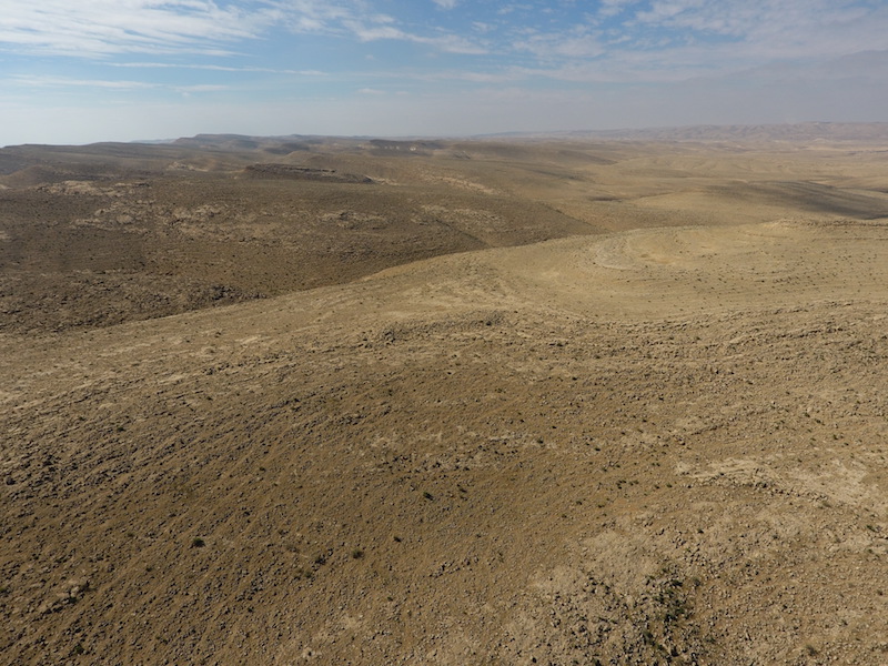
Ecotourism at the park – The Park and lake are a landing site for migrating birds, providing an ecosystem for a wide variety of plants and animals. The Duchifat Center for Birdwatching, Ecology and Scorpions is located at the Park. The Duchifat center rings and compiles information on birds going through the Park. The Park is one of the four national ringing stations. The Duchifat Center conducts “bio-blitz” events at the Park. Yeruham Crater is the Big Crater (precisely: Hatira Crater). It is an erosional crater at the Negev Mountain, one of several similar craters in the area, formed in a similar manner. It is elliptical in shape and it is the second largest Negev crater. It is located at the Hatira Anticline, thus its additional name. The crater is 14 Km long and 6 Km wide. Its maximum depth is 410m. It is the drainage point for Hatira Stream. The crater’s boundaries are marked by the Hatira Mountains in the west and the Karbolet Mountain range in the east and south, part of the Israel National Trail. The Big Crater consists of an area of colored sand, revealing layers of colorful sandstone that disintegrates when touched and reveals a wide variety of colors.
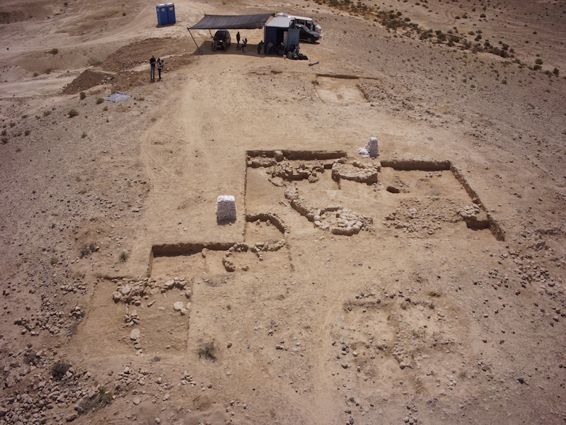
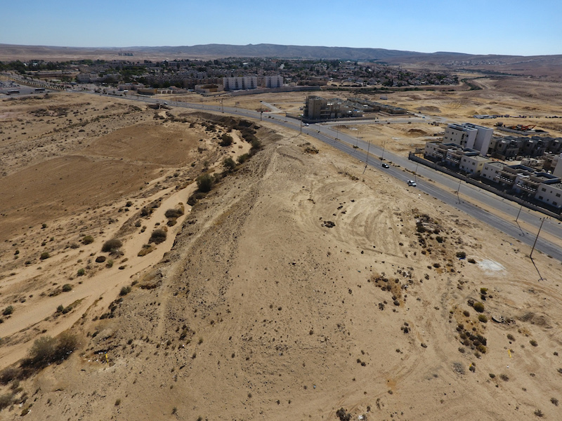
The Israeli Fortress dates back to the 10th century B.C., the days of Solomon, Rehoboam and the Shoshenq journey, located to the east of Vardimon Blvd., north of Avnon Stream. This is the largest fortress of its kind in the Negev and the first four days of digging in April 2018 already revealed important findings, including a casemate typical of the period, pottery dated to the First Temple, a site suspected of being a household alter, olive pits, legumes and more. The fortress marks the eastern border of a large site from the Middle Bronze Age (2000 B.C.), spanning both sides of Vardimon Blvd. over the Avnon Stream. Select segments of this site were dug up in a salvage archeology mission prior to constructing the northern neighborhood, revealing evidence of the significance of the site in the process of copper production, trade and processing. Inter alia, the diggers found copper bars originating from Punon in Jordan. Remnants of kilns used to melt the copper can be seen among the new houses. The ancient Yeruham Stronghold is approximately 1 kilometer southwest of the entrance to Yeruham at the Northern Negev Mountain. Situation on the southern bank of Shualim Stream, about 1 kilometer south of the entrance to Yeruham. The stronghold is in Tel Rahma, where Rahma is derived of the Hebrew name of the Egyptian Vulture. The Nabataean-Roman fortress protect the ancient route from Ovdat to Mamshit. The signs posted along the restored site tell the story of the fortress and describe the ancient regional roadmap. Archeological digs in the area uncovered pottery and ostracons bearing Greek writing, as well as town remnants including streets, structures and a fortress wall and tower. The Stronghold was only partially restored. The Yeruham Well, also known as Hagar’s Well (Bir Rahma), is an ancient well, most probably used as a water source for the fortress to its southwest. During the British Mandate, the British refurbished the well for the Bedouins in the region and, in Operation Ovda in March 1949, it served as an assembly point for the Golani Brigade en route to conquer the Southern Negev and Eilat. The Yeruham Well is located at the eastern side of Yeruham Park. Yeruham Lake Park. Yeruham was founded as a shantytown in the Northern Negev Mountain. Its name is derived of a Negev site mentioned in an inscription by Pharaoh Shoshenq dated to the 10th century B.C. (925 B.C.). It was initially called Tel Yeruham and later renamed Kfar Yeruham. Its first residents were new immigrants from Romania. Yeruham was granted local council status in 1959 and it was further populated by immigrants from Morocco and India. For many years, the town suffered from a shortage of employment opportunities, social problems and desertion. Efforts were made in the 1970’s to establish factories in Yeruham to provide employment for its residents. Yeruham is still considered among the poorest Jewish towns in Israel.
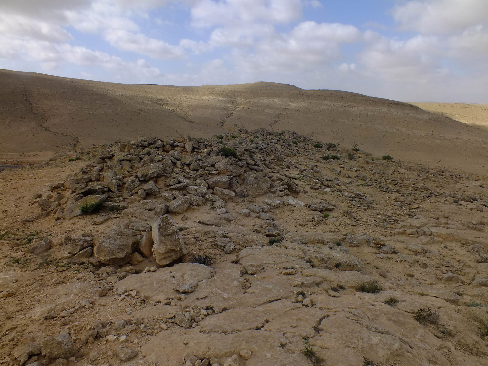
Of the structures, all that remain are remnants of the walls to the westernmost structure, structure foundations and concrete floors. Except for the northernmost structure of the compound, assumed to have been used as a dining or assembly hall, no one knows what the structures were used for. There were probably only two structures at the southern compound, covering ~1,200m² and located about ~150m south of the residential compound. Nothing but the wall and room outline remains of the eastern structure, typical to mandatory military construction and all that remains of the western structure are the two parallel walls of the narrow construction, probably used as restrooms and showers. The Soling trail – In addition to the workers’ camp, the Iraqi Petroleum Company paved a road using soling technology, a popular British technology: a compact layer of soil covered by a layer of crushed limestone and a layer of asphalt, compacted with a steamroller. Remains of a concreate foundation for a drilling tower used for the oil surveyors at the Avnon Mountain Camp were found at the center of the Crater, near the road. This historical route is now the access route to the site. Observation point – ~150m from the northern camp is the peak of the mountain reaching 580m above sea level, offering a breathtaking view of the Big Crater and its surroundings. Historical background: The British workers’ camp at Avnon Mountain was established by the Iraqi Petroleum Company (IPC) in the early 1940’s in order to provide housing for workers seeking oil in the Crater area. Efforts to find oil began in Israel before WWI, but the efforts were halted due to the low probability of finding oil in Israel. A geological survey conducted by the Mandate regime in the 1930’s once again raised the idea of oil in Israel and the Mandate government renewed the oil seeking licenses. The license in Israel was granted to POP (Petroleum Development Palestine), an IPC subsidiary that operated in Israel and constructed the workers’ camp at Avnon Mountain. The first drilling site was at Hulikat (Heletz) and there was another site at the Big Crater, assuming that the natural erosion would enable closer contact with potential oil layers. The workers’ camp at Avnon Mountain was establish to support this drilling. After several trial drillings, oil search at the Crater was discontinued due to regional instability and were eventually terminated in 1947. In 1941, in order to accommodate the oil drillings, the British paved an access route of ~17 Km from the Negev Junction to the center of the Big Crater. The road (later called the “Oil Road” and eventually the road leading to the Aravah) was kept a secret due to the confidential nature of oil drilling, it was not marked on any map and its existence was only discovered years later, after the IDF conquered the Negev. A new road was paved ~20 years ago, leaving the old Oil Road, alongside the modern road, to slowly disintegrate over time.
The colorful sand area offers a tourist attraction. In addition, the Crater is filled with fossils, including remains of corals, ammonoids and crinoids. This area is considered a protected nature reserve. Ma’aleh Avraham leads from the bottom of the crater to the top, near its southeastern corner. The trail was opened for SUV’s by a paratrooper unit and it is named after Avraham Krinitzy, the mayor of Ramat Gan – the city adopting the Paratrooper Brigade. Upon reaching the top of the trail, near the topographical peak of the Hatira Ridge, one can enjoy a breathtaking view of the Big Crater alongside a memorial marking its opening. During the British Mandate, attempts were made to utilize the natural resources at the Crater. The British even drilled there in an attempt to find oil, but to no avail. Clay and sand were mined there after the State was born. Negev Industrial Minerals Ltd. established the Hatira factory in the Crater for mining, drying and sifting quartz sand. Northwest of the Big Crater is Avnon Mountain, 656m high, providing a nice view of the Crater. The Matmor Mountains, reaching a peak height of 494m, are at the center of the Crater. The Big Crater was discovered prior to the discovery of the larger Ramon crater and its name is derived of the fact that it is larger than the second crater known at the time – the Small Crater. The Crater is southeast of Yeruham and so Amram Mitzna, Yeruham’s mayor, suggested renaming it “Yeruham Crater”. The Avnon Mountain site is located in a declared natural reserve on the edge of the Crater between Avnon Mountain and Rte. 225, about 3 KM southeast of Yeruham. The site was established by the Iraqi Petroleum Company (IPC) in the early 1940’s as a British workers’ camp drilling for oil in the nearby crater and it consist of two areas of structures intended for worker residence and related needs.
When the site was deserted in the late 1940’s, after attempts to find oil failed, IDF destroyed the structure lest they be used by infiltrators. Only the ruins remain at the site, comprising the only physical evidence of Negev oil excavations toward the end of the British rule in Israel. The workers’ camp at Avnon Mountain is typical to British work and military camps during the Mandate. It presents the British “light” construction technology for industrial or quick building, which was characteristic of British camps or temporary facilities, providing the only remnant of such a camp from Mandate days in Israel. The camp consists of two compounds – north and south – separated by a dirt road. The assumption is that the separation was intended to separate the southern residential and related structures from the northern public structures, such as the dining hall or other administrative oil seeking matters.
The northern compound, covering ~3,000m² and located ~30m north of the mountain access route, one can see the remnants of 5 structures – 3 rectangular structures, almost equal in size, arranged in semicircle open to the west, creating an inner courtyard, and two small structures at the corners.